


Our Knowledge
Starting with a long heritage of family entrepreneurs, Jarett Svihra is keeping the family’s tradition moving at an expeditious pace. Already the President and CEO of Global Sign located in Beaver Falls, PA, he has decided to move forward in helping the development of the natural gas surge in the Northeast United States. Mainly by helping landowners build acreage blocks to heighten initial lease offers.
Mr. Svihra born and raised in Beaver County located within Western Pennsylvania’s natural gas booming region was contentious about the natural gas drilling industry moving into the area. It was scary at first, not only for the environment, but also for the landowners. Pennsylvania was already full of stories of low-ball leases in which landowner’s were taken advantage of. When he himself was under paid for signing some of his properties to long-term gas leases, he saw the potential to help landowners within the local region. This automatically got him moving in a direction that could potentially help others that made or would have potentially made the same mistakes. Landowner’s that are contemplating Oil & Gas Development thru-out Western PA and Eastern OH should consider our process. We continue to place the proper personnel for our expanding clientele base and have positioned ourselves as one of the industries elite oil & gas landgroup builders.
Mr. Svihra an already successful entrepreneur, with past & present businesses in everything from precious metals reclamation, plastic recycling and also including many retail establishments, has always looked forward to the more challenging aspects of developing future companies. Selling a service of good faith in helping landowner’s within the region is much more satisfying than selling a product. It is time to help the community through rough times. The opportunity that is in front of the Northeast region will for sure give many families, their children and future generations a lifestyle that most could not even dream of. It is Northeast’s job to help build and protect that opportunity thru a landgoup building process, which is the only proven method in adding increased value to landowners that are interested in obtaining Oil & Gas Lease offers.
We highly advise that after these offers have been presented that the landowners seek legal representation. We have a large list of attorney firms that we recommend for this process.
Below we have prepared additional educational information in regards to the Marcellus and Utica Shale Plays along with maps and useful tools.
What is Marcellus Shale
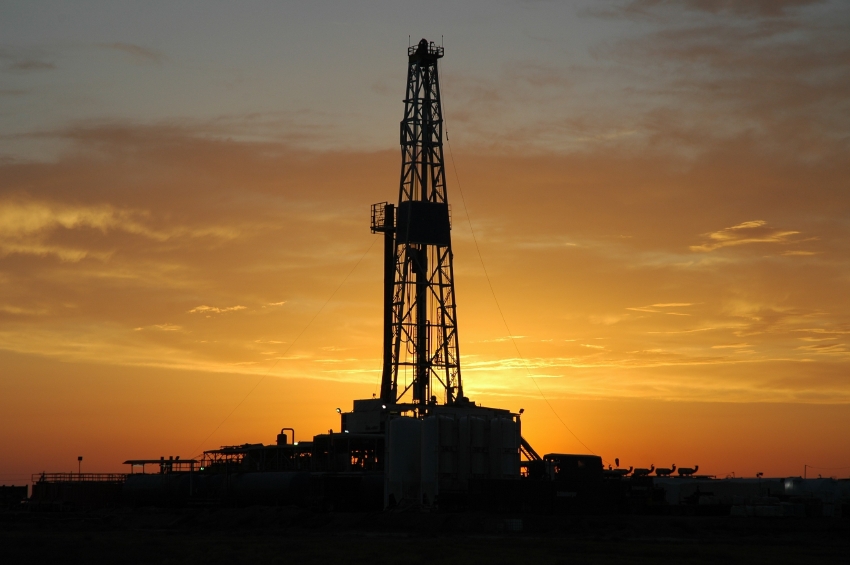
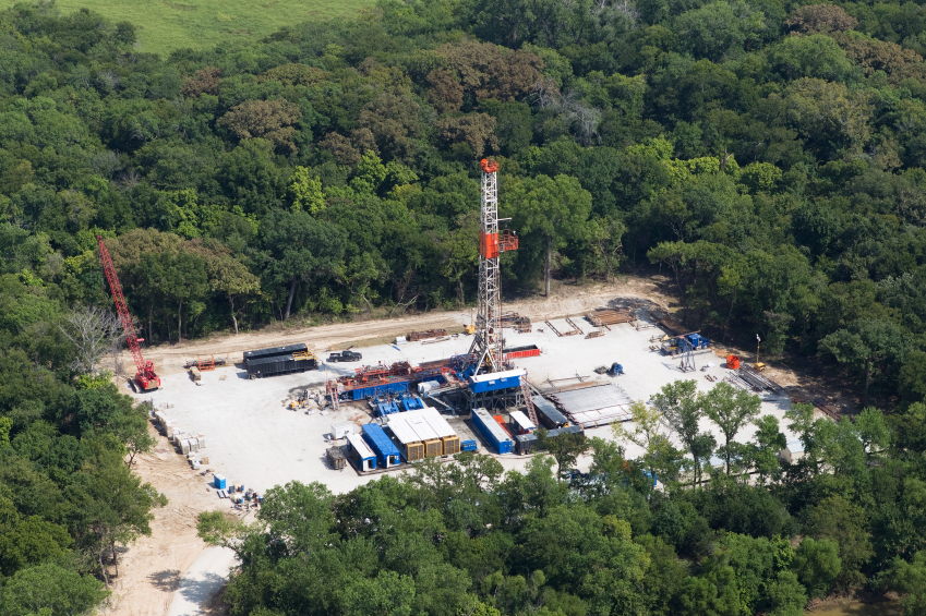
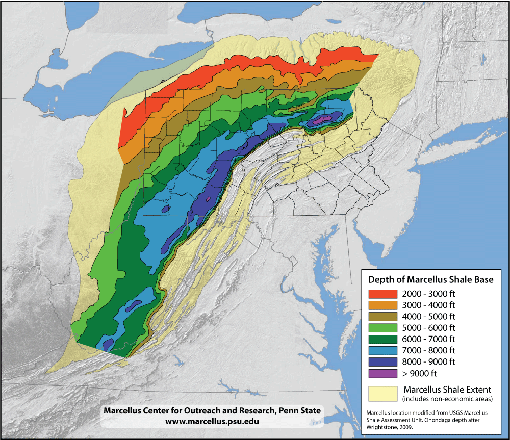
The Marcellus Formation, also classified as the Marcellus Subgroup of the Hamilton Group, Marcellus Member of the Romney Formation, or simply the Marcellus Shale, is a mapped bedrock unit in eastern North America. It is a sedimentary rock formed from marine deposits. Named for a distinctive outcrop near the village of Marcellus, New York in an 1839 geological survey, it extends throughout much of the Appalachian Basin. The energy development community is drilling deep beneath the Allegheny Plateau to reach its largely untapped natural gas reserves located near the high-demand markets along the East Coast of the United States.
Stratigraphically, the Marcellus is the lowest unit of the Devonian age Hamilton Group, and is divided into several named sub-units. Although black shale is the dominant lithology, it also contains lighter shales and interbedded limestone layers due to sea level variation during its deposition almost 400 million years ago. The black shale was deposited in relatively deep water devoid of oxygen, making it only sparsely fossiliferous. Most fossils are contained in the limestones, and the fossil record in these layers provides important paleontologal insights on faunal turnovers. The black shales also contain iron ore, uranium and pyrite, and the fissile shales are easily eroded, presenting civil and environmental engineering challenges.
What is Utica Shale
The Utica Shale is a rock unit located a few thousand feet below the Marcellus Shale. It also has the potential to become an enormous natural gas resource. The Utica Shale is thicker than the Marcellus, it is more geographically extensive and it has already proven its ability to support commercial production.
It is impossible to say at this time how large the Utica Shale resource might be because it has not been thoroughly evaluated and little public information is available about its organic content, the thickness of organic-rich intervals and how it will respond to horizontal drilling and hydraulic fracturing. However, the results of early testing indicate that the Utica Shale will be a very significant resource.
The potential source rock portion of the Utica Shale is extensive. In the United States it underlies portions of Kentucky, Maryland, New York, Ohio, Pennsylvania, Tennessee, West Virginia and Virginia. It is also present beneath parts of Lake Ontario, Lake Erie and part of Ontario, Canada. If the Utica is commercial throughout this extent it will be geographically larger than any natural gas field known today.
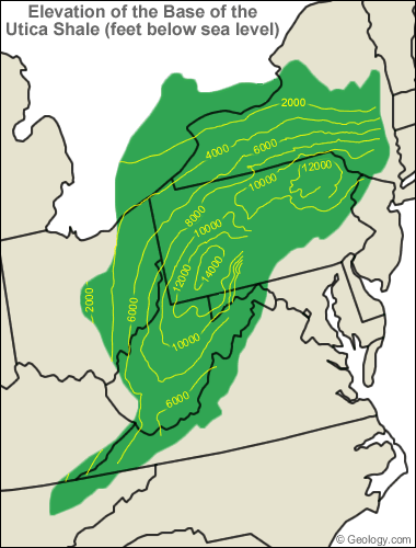
The Utica Shale is much deeper than the Marcellus. The Utica Shale Elevation Map has contour lines that show the elevation of the base of the Utica Shale in feet below sea level. In some parts of Pennsylvania the Utica Shale can be over two miles below sea level. However, the depth of the Utica Shale decreases to the west into Ohio and to the northwest under the Great Lakes and into Canada. In these areas the Utica Shale rises to less than 2000 feet below sea level. Beyond the potential source rock areas the Utica Shale rises to Earth's surface and can be seen in an outcrop located near the town of Donnacona, Quebec, Canada.
Most of the major rock units in the Appalachian Basin are thickest in the east and thin towards the west. The rock units that occur between the Marcellus Shale and the Utica Shale follow this trend. In central Pennsylvania, the Utica can be up to 7000 feet below the Marcellus Shale but that depth difference decreases to the west. In eastern Ohio the Utica can be less than 3000 feet below the Marcellus.
In the navigation bar to the left are maps showing the Marcellus Shale & Utica Shale coverage area and a link to our natural gas royalty calculator.


Click Here To Visit The PA Bureau Site
Oil & Gas Operators Manual
Click Here To Read Operators Manual